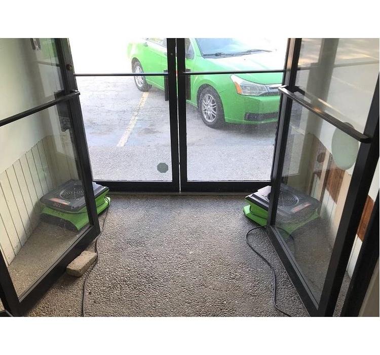
Recent Storm Damage Posts
How to Deal With Frozen Pipes in Winter Weather | SERVPRO of Fenton/South Ballwin
1/31/2024 (Permalink)
 Frozen pipes? Call SERVPRO of Fenton/South Ballwin
At SERVPRO of Fenton/South Ballwin, we often see an increase in water losses during the winter. A major culprit of these losses are frozen pipes.
When the water inside the pipes freeze, its molecules expand, which causes a blockage of ice that prevents unfrozen water from passing through. When the frozen pipe begins to thaw, the pressure from the water can cause the pipe to burst.
How Can I Tell My Pipes Are Frozen?
One of the most common signs that you are dealing with frozen pipes is when you turn on your faucet and no water comes out (similarly, if you flush your toilet and it doesn’t refill). If this happens, you should check your water source to make sure it’s still turned on and that a leak isn’t occurring.
Another tell-tale sign of frozen pipes is when your water line is coated in frost or is bulging.
If you know that your pipes are frozen, you can either choose to address the issue yourself or call in professionals.
How to Prevent Frozen Pipes
Frozen pipes cause an estimated $400-$500 million in damage annually. To avoid adding to that total, there are several steps you can take.
When the weather gets cold, you should drain water from pipes that are likely to freeze, such as sprinkler and swimming pool water supply lines. Outside hoses should also be disconnected and drained, and indoor valves supplying these access points must be closed.
On frigid days, let your faucets drip cold water. Having the water drip out will make it harder for the water in the pipes to freeze. Your thermostat should also be kept around the same temperature at all times, and your house temperature should never fall below 55 degrees. Garage doors should also be kept shut to protect water lines.
If you are worried about your pipes freezing, you can also place a 60-watt bulb in the areas you’re concerned with. Just make sure none of the materials near the bulb are combustible.
What If My Pipes Are Already Frozen?
If you realize your pipes have frozen, the first step is to keep your faucet open. This will help with thawing and allow for moving water to flow through the pipe.
You can also apply heat to the specific area of the pipe that is frozen. You can do this by wrapping an electronic heating pad around the pipe or heating the area with a hair dryer. Using towels soaked in hot water can help, too.
Keep applying heat until water flow returns to normal. After the pipe has been thawed, turn on other faucets around the house to make sure you don’t have any more frozen pipes.
If the pipe is inside an exterior wall, you should immediately call a professional contractor. It is likely that a hole will need to be cut in the wall toward the inside of the house to allow the pipes to be exposed to warmer air.
Frozen pipes can be a catastrophic problem for your home, but taking proactive measures can help you address the problem before it even starts.
Heat Safety
5/6/2020 (Permalink)
As summer approaches, it is time to consider safety precautions for extreme heat in the coming months. Heat affects all people, but especially the young, elderly, sick and overweight. According to the EPA, "the sun can heat dry, exposed urban surfaces, such as roofs and pavement, to temperatures 50-90 degree hotter than the air, while shaded or moist surfaces-often in more rural surroundings-remain close to air temperatures."
If you must go outside, wear loose-fitting, light-colored clothing, and be sure to apply sunscreen often. Pay attention to signs of heat exhaustion, which are heavy sweating; weakness; cold, pale and clammy skin; nausea or vomiting; and fainting according to the Center for Disease Control and Prevention (CDC). Heat exhaustion can lead to heat stroke, which is life-threatening. Signs of heat stroke are a high body temperature (103+), rapid and strong pulse, and possible unconsciousness. If you think someone has heat stroke, call 911 immediately and move the person somewhere cool.
Extreme heat is a serious danger. For more information on preparation and prevention, visit ready.gov or cdc.gov.
National Building Safety Month
4/30/2020 (Permalink)
 Making sure communities are prepared for natural and manmade disasters.
Why is Building Safety Month important today?
For the last 40 years, the Cod Council, its 64,000 members, and a diverse partnership of professionals from the building construction, design and safety communities have come together to celebrate Building Safety Month.
Building Safety Month provides education for the public about solutions that improve the safety, sustainability and resiliency of buildings, infrastructure and communities. Properly administered and up-to-date safety codes reduce loss of life and property damage.
WEEK ONE - Disaster Preparedness
WEEK TWO- Water Safety
WEEK THREE- Resiliency, Sustainability, Innovation
WEEK FOUR- Training the Next Generation
Call us today to set up an appointment to establish your Emergency READY Profile
Prepare now for Spring Floods
4/28/2020 (Permalink)
– According to the National Weather Service, there is the potential for Missouri to experience serious flooding again in only a few weeks. Last year’s damage repairs are ongoing, while emergency managers, meteorologists, engineers, farmers, and residents monitor weather forecasts, anticipating another spring flood season.
FEMA’s National Flood Insurance Program (NFIP) is a great way to protect your home, business, or personal property. According to NFIP, just six inches of water can cause $52,000 in damage to your home. Statewide, NFIP paid more than $70 million in flood insurance claims to Missouri policyholders for damage in 2019.
After 2019’s historic flooding, one action residents and business owners should take immediately is to review their current flood insurance coverage or consider purchasing a flood insurance policy if they don’t have one. Did you know most homeowner and business multi-peril policies do NOT cover flood damage? A new policy takes 30 days to go into effect. Other key facts you should know:
- Flood insurance can pay up to $250,000 for damage to your house and up to $100,000 for contents.
- Business owners can purchase coverage up to $500,000 for structures and up to $500,000 for contents.
- Flood insurance pays for covered flood damage regardless of whether there is a federal disaster declaration. The average annual cost of an NFIP policy for homeowners is about $700.
- Anyone can buy flood insurance if your community participates in the National Flood Insurance Program (NFIP), no matter where your home or business is located. Check with your local officials to find out if your community participates.
- Almost 25 percent of flood insurance claims come from areas not considered at high risk for flooding. Individuals and business owners are encouraged to look over their own emergency plans and update as necessary to ensure they are sufficiently prepared. Ask these crucial questions:
Remember, once you purchase a policy, it takes 30 days for the coverage to go into effect. Anywhere it rains, it can flood. Before the rivers rise, have your policy in place.
- If you already have a policy – is your coverage amount adequate?
- Do you have BOTH structure and contents policies? These are separate coverage policies and amounts. Ask your insurance agent.
- Do you rent? You can buy coverage for your personal property. Ask your agent about renter’s flood insurance.
- Current soil saturation is above average for this time of year. Snowmelt runoff from the Rocky Mountains and ice jams on northern rivers all contribute to the amount and force of water flowing through the Missouri and Mississippi river systems. After two consecutive years of heavy moisture, flooding is a significant part of the 2020 spring outlook. Consider the flood risk and act now to protect yourself, your family, your business, or your property.
If your home or business is affected by spring flooding call SERVPRO of Fenton/South Ballwin. We are always here to help.
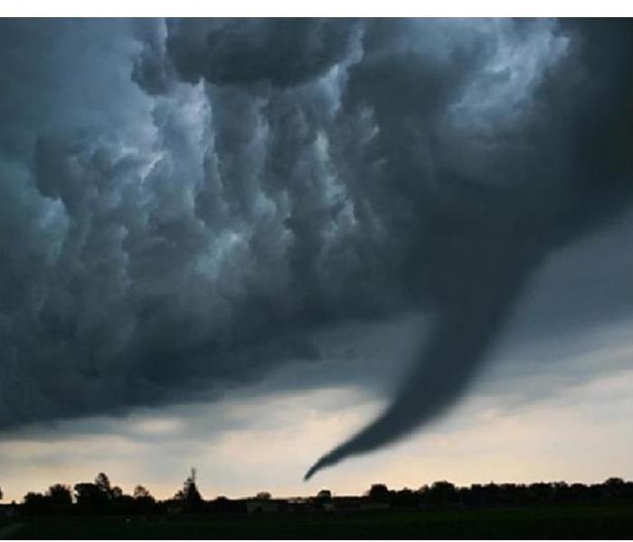
Tornadoes.....Safety and SERVPRO Tips
4/16/2020 (Permalink)
To be ready for the potential danger a tornado brings may seem impossible, but just like all storms…. the key to survival is being prepared! Tornadoes are a bit more popular in the southern states we refer to as “Tornado Alley” and I am sure most of us reading this have never witnessed the destruction and loss of life a tornado can cause. This still doesn’t mean that we ignore or ill prepare our homes and places of business. Here at SERVPRO we have a few tips!
For starters, you need to put together a Safety Kit. This kit should include everything from three days of drinking water, food (nonperishable), basic first-aid supplies, a battery powered radio, and flashlight supplies. Please Be Aware of your weather warning system, both where your home and place of business reside. It is important to know which days are drills, your designated safety location to relocate, and to stay updated on any changes. Then when or if the situation occurs Do Not Open Your Windows. In no way does opening a window save on the impact or damage a tornado will bring. This only gives debris and rainwater easy access to enter and damage the building. Finally, If You Are In An Automobile it is important to get to the nearest building and the lowest level possible. Find a safe location, possibly under a solid piece of furniture like a desk or under a basement staircase.
To explore the option of having a more detailed emergency plan contact SERVPRO of Fenton/South Ballwin (636)527-5990. We are here to help and can aid in the production of creating an Emergency Response Profile for your home or business!
How to Beat the Freeze
1/12/2020 (Permalink)
Once the temperature starts dropping outside, you should take measures inside to keep your pipes warm and water running. Research conducted by the Building Research Council at the University of Illinois shows that the “temperature alert threshold” is 20° F, especially if you have uninsulated pipes running through an uninsulated space.
Some of the steps experts recommend may go against your better instincts of conserving water and heat, but the extra expense is nothing compared with a hefty repair bill. Here’s what to do:
Keep garage doors closed, especially if there are water supply lines in the garage.
Open kitchen and bathroom cabinet doors to allow warmer air to circulate around the plumbing, especially if your sinks are on an exterior wall. (If you have small children, be sure to remove any harmful cleaners and household chemicals.)
Let the cold water drip from a faucet served by exposed pipes. Running water through the pipe—even at a trickle—helps prevent pipes from freezing.
Keep the thermostat set to the same temperature during day and night. Again, during a cold snap is not the time to set back the thermostat at night to save a few bucks on your heating bill.
If you plan to be away during cold weather, leave the heat on in your home, set to a temperature no lower than 55° F.
For the long term, add insulation to attics, basements, and crawl spaces. Insulation will maintain higher temperatures in those areas. And to prevent drafts, seal cracks and openings around windows, doors, and at sill plates, where the house rests on its foundation. SERVPRO of Fenton/South Ballwin is available 24/7/365 to assist if you have damage due to frozen pipes.
How to protect your home from Flooding
10/28/2019 (Permalink)
When protecting your home from flood damage, assess the risk flooding poses in your region and your house specifically. You should then try to carry out a range of preparations and renovations, such as applying a sealant to any foundation cracks and checking with your insurance company to determine if any addition coverage for flooding is available.
The first step to flood protection is to determine how likely you are to suffer a flood in your area, and how well your house is built to withstand it. The FEMA Flood Map Service will show you the general flood risk of your region. After you enter your zip code, click "View web map," to see your area's flood zones, and click "show all products for this area," to see reports of your region's flood history.
Here are some areas to improve the flood protection of your home:
- Install foundation vents, or a sump pump
- Check with your insurance agent for additional coverage
- Repair any foundation leaks or cracks
- Raise your electrical outlets and switches
- Grade your lawn away from the house
- Make sure gutters are clear and direct water away from the house
For any additional questions on how to protect your home or business from flooding call us at (314) 858-1688
What is lurking in flood waters?
4/11/2019 (Permalink)
 Flood Waters
Underneath the surface of flood waters can be an abundance of danger: both living and non-living. The Environmental Protection Agency requests that everyone limit their exposure to flood waters. The agency states that flood waters may have high levels of raw sewage from both humans and animals embedded in the waters. In addition to that, many plants, factories, and farms may be overrun with flood waters, and some of those can leak toxic materials into the water, such as an oil refinery or nuclear plant. These issues can affect water mains, well water, and lines that can bring contaminated water into dry homes that may not even be flooded.
Unwanted animals may be lurking underneath the waters as well: crocodiles, snakes, fire ants, and even, if you're along a coastline, sharks.
On top of that, mold and standing water can both lead to unwanted visitors inside your home. Mosquitoes and insects tend to live, breed, and thrive in standing water, and mold growth can spike in the event of moisture. Getting rid of standing water near your home, in gutters, old tires, plastic covers tarps, pools, and buckets can certainly help.
While we can't totally alleviate the effects of flooding during severe weather, developing a flood plan for your family can help out.
Create a barrier of protection for areas that can be inundated with floodwaters, by way of perhaps sandbags. Additionally, secure food and water for your family in the event that clean, drinking water is scarce.
Officials urge storing in a cool place, at least 3 days of water for each individual person. Do not use or drink contaminated water for anything: brushing your teeth, washing dishes, making ice, or preparing food.
After the Storm, keep older and younger people with sensitive immune systems out of the home until your home or business can be restored by SERVPRO of Fenton/South Ballwin. We are here to help 24/7/365. 314-858-1688
Board-up: Securing your home or business
3/30/2019 (Permalink)
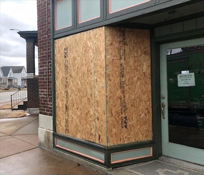 Fitted insert board-up
If doors or windows have been damaged or destroyed in a fire, rain and wind may enter the building and cause further damage. Also, curious onlookers or vandals may attempt to enter a damaged building. To help prevent these problems, it may be necessary to "board-up" the property.
The board-up procedures should provide durable protection for the damaged structure and cause minimal additional damage to building surfaces. Board-up methods include:
- Cover-over
- Fitted inserts
- Bolt tension
- Tarps and shrink wrap systems
The cover-over system is easy to install and probably most applicable on roofs. Large expanses of roof can be covered quickly with heavy-duty tarps. Fitted insert board-ups are more difficult to install but are more weather tight than the cover-over system.
Bolt tension methods are relatively easy to install and have the advantage of being weather resistant and difficult for intruders to disengage. Placing carpet or carpet pad on the interior brace will prevent additional damage to wall surfaces.
Why March Brings the Most Variety of Extreme Weather in the U.S.
3/18/2019 (Permalink)
When March arrives, what are the first things you think of? Spring, baseball, flowers blooming?
The atmosphere in March is often much less tranquil. Based on history, one could make an argument that March consistently sees the greatest variety of dangerous weather of any month in the U.S.
Why is this the case?
By definition, spring is a transition time between the persistent cold of winter and the heat of summer. The sun is increasingly higher in the sky each day, and there's increasing daylight, allowing the air to warm more efficiently.
At the same time, there's still lingering snowpack and colder air in Canada and parts of the northern and western U.S. in March.
Superimposed on this tension between increasing warmth and lingering cold is a still-active March jet stream, often taking large southward plunges over the U.S.
When this happens, the potential energy of the temperature contrast gets released in the form of an intensifying low-pressure system that can spawn a snowstorm, severe weather outbreak, rainfall flooding, coastal flooding and high winds.
Perhaps the most recent March poster child for such a storm with multiple facets was the aptly named Superstorm of March 12-15, 1993.
It began with a squall line of severe thunderstorms racing across the eastern Gulf of Mexico, driving storm surge over much of Florida's Gulf Coast. That squall line then raced across the Florida Peninsula, spawning 11 tornadoes. Wind gusts up to 109 mph were clocked in the Dry Tortugas, west of Key West. Havana, Cuba, suffered a blackout due to the high winds.
(MORE: Historic Coastal Floods in the East)
To the north, whiteout conditions were reported in Atlanta, 6-foot drifts were seen near Birmingham, Alabama, and double-digit snowfall fell in 20 states from Alabama to Maine. Thousands were isolated by snow in the Southeast, and over 200 hikers needed to be rescued in the Smoky Mountains.
For the first time in history, every major airport on the East Coast was closed for a period of time due to this storm.
While not every March storm is a "Superstorm", the history of March storms is a long one. Here are some highlights by impact.
Snowstorms
Multiple parts of the county have seen their share of powerhouse March snowstorms.
(MORE: Where March is the Snowiest Month)
These snowstorms often either hook out of the Rockies into the Plains, or track up the East Coast.
In mid-March 2017, Winter Storm Stella hammered the interior Northeast with up to 4 to 5 feet of snow, a record snowstorm for Binghamton, New York.
Denver's second heaviest snowstorm was a mid-March 2003 whopper, when over 2.5 feet of snow in less than two-days' time effectively shut down the city.
(MORE: 4 Dangers of Heavy, Wet Snow)
Just four days after spring officially arrived, over 6 inches of snow buried a swath from Atlanta to Charlotte to Raleigh in 1983.
The deadliest March snowstorm was the infamous Blizzard of 1888, which dumped 40 to 60 inches of snow in New York, Connecticut and New Jersey, wind-whipped into drifts which topped some homes. Four hundred were killed in the storm and its cold aftermath.
Here are a sampling of other notable March snowstorms:
- Late March 1987: Three-day blizzard produced gusts to 78 mph at Dodge City, Kansas and Altus, Oklahoma. Pampa, Texas, picked up 20 inches of snow. Forty-six Kansas counties declared disaster areas.
- Early March 1966: Blizzard across North Dakota, Minnesota produced wind gusts to 100 mph, whipping snow into drifts 30 to 40 feet high, paralyzing travel for three days.
- Early March 1717: Four separate snowstorms hit the East in nine days, with up to 4 feet of snow in Boston and drifts to 25 feet in Dorchester, Massachusetts.
Tornado Outbreaks
While severe weather can occur any time of year the ingredients align, March is typically when arctic fronts become less potent enough to allow warm, humid air to surge north more often in their wake ahead of vigorous jet-stream disturbances swinging out of the West.
The tornado threat tends to be highest in March in a corridor from the Southern Plains into the Tennessee Valley and Deep South. Central Florida can also be a tornado hot spot in March.
(MORE: Tornadoes in March)
On March 2-3, 2012, 75 tornadoes were spawned from the Ohio Valley to the Deep South, killing 40. EF4 tornadoes hit Henryville, Indiana, and Crittenden, Kentucky. EF3 tornadoes hit West Liberty, Kentucky, and damaged the Paulding County, Georgia Airport.
Occasionally, these outbreaks occur farther north, when unusually warm and humid air intrudes ahead of a powerful jet stream and frontal system.
On March 29, 1998, 14 tornadoes, 13 of which were spawned from one supercell, tore through southern Minnesota, including the towns of Comfrey and St. Peter.
Even in what most conventionally think of as "tornado alley", the March 13, 1990, outbreak was a massive outbreak for March.
Fifty-nine tornadoes were spawned in Oklahoma, Kansas, Nebraska and Iowa, including a pair of F5s in Hesston and Goessel, Kansas. These were the strongest tornadoes reported so far northwest in the U.S. so early in the season.
Perhaps the most infamous March outbreak was the Tri-State Tornado Outbreak in 1925, claiming 747 lives in seven states on March 18, 1925.
According to Dr. Greg Forbes, severe weather expert for The Weather Channel, recent research has found that instead of being one single tornado, it's now believed a family of at least three tornadoes had a combined path of at least 235 miles in Missouri, Illinois and Indiana.
Here are some other notable severe weather and tornado events in March:
- March 28, 2000: Back-to-back tornadoes struck Ft. Worth, then Arlington, Texas, shattering windows, killing three.
- March 25, 1992: Hail up to 4 inches in diameter pelted the Orlando metro area, virtually shutting down the area's nursery industry due to broken glass.
- March 28, 1984: At least 22 tornadoes tore through the Carolinas, including a 2.5-mile wide F4 near Tatum, South Carolina
- March 25, 1952: Deadliest outbreak in Arkansas history, with 111 dead. In all, tornadoes claimed 343 lives in the South. One F4 tornado leveled the town of Judsonia, Arkansas.
- March 20-22, 1932: One of the worst outbreaks in U.S. history from Mississippi to South Carolina to Indiana. Ten F4 tornadoes tore through Alabama, Georgia and Tennessee on March 21 alone.
Floods
Snow melting quickly during a sharp warm spell can and often does trigger spring flooding.
Some of the most serious flooding occurs when heavy rain falls in the spring as the ground is still soaked from absorbing spring meltwater.
For this, March is almost synonymous with flooding in the Ohio Valley.
The early March 1997 flood was the highest in Cincinnati since 1964, and in some places in 60 years. Parts of the Ohio Valley picked up 10 to 13 inches of rain, sending the Ohio River and its tributaries into major flood.
During the heart of the Dust Bowl, a mid-March "great flood" in 1936 set records in Pittsburgh, with additional flooding stretching as far northeast as Maine.
(MORE: Flood Disasters More Common Inland)
Another destructive "great flood" in March 1913 was estimated to have claimed at least 1,000 lives, swamping the Miami River Valley of Ohio, including Dayton.
Most recently, over 21 inches of rain triggered record flooding in parts of east Texas, Louisiana and Mississippi in March 2016. Particularly hard hit were the cities of Monroe and Shreveport, Louisiana, as well as the Sabine River.
East, West Coast Storms
We earlier mentioned the 1993 Superstorm as perhaps the ultimate, recent example of March's fury.
Certainly there are other examples of fierce nor'easters in March, including a late March 1984 storm that produced nearly 100 mph winds at Martha's Vineyard, and the infamously destructive Ash Wednesday 1962 storm along the Mid-Atlantic seaboard.
Some March storms in the West can pack heavy snow, high winds and flooding rain.
From March 16-27, 2011, Tahoe City, California, picked up 82.5 inches, just under 7 feet, of snow.
In that same storm siege, over 11 inches of rain fell in the mountains above Santa Barbara, California, and winds gusted to 110 mph in Big Bear, California.
By early March 1983, snow depths at Lake Tahoe reached 215 inches, prompting officials to warn cross-country skiers to avoid skiing into power lines buried by the massive snowpack.
Up to 18 inches of rain fell in parts of the L.A. Basin during that storm parade, punctuated by a pair of tornadoes on March 1, 1983.
An 8-foot wall of water roared down Santa Ana Canyon on March 3, 1938, after torrential rain, swamping areas between Santa Ana and Huntington Beach. Nineteen were killed and 2,000 were left homeless by this flood.
Another 113 lives were lost in flooding along the Los Angeles River from that 1938 event.
Here at SERVPRO of Fenton/South Ballwin, over the last 15 years we have seen first hand all kinds of weather extremes.
We are here to help 24/7/365 to help if your family or community is affected by any weather patterns. 636-527-5990
Jon Erdman-weather.com
Tornado Safety- What Should You Do?
3/11/2019 (Permalink)
Spring is just around the corner, the time of year when tornadoes are most common. However, powerful storms such as the ones which recently occurred in Alabama can happen at any time of the year. In fact, some experts say new parts of the country may see an increased threat of tornadoes in their areas.
TORNADO FACTS
- Tornadoes can happen anywhere, at any time of day but are most likely to occur between 3:00 and 9:00 p.m.
- The United States receives more than 1,200 tornadoes every year.
- The National Oceanic and Atmospheric Administration (NOAA) reports there were as many as 800 confirmed tornadoes in 2018.
- NOAA also reports the four deadliest states for tornadoes are Alabama, Missouri, Tennessee and Arkansas.
- Most tornadoes occur east of the Rocky Mountains.
- The area where we see the most tornadoes seems to be moving from the Plains states to the Southeast and Midwest, especially to states along the Mississippi River.
TORNADO SAFETY
- KNOW YOUR COMMUNITY’S WARNING SYSTEM. There are different ways to notify people about tornadoes. Many communities use sirens intended for outdoor warning purposes.
- · IDENTIFY A SAFE PLACE IN YOUR HOME where you can gather – a basement, storm cellar or interior room on the lowest floor with no windows. In a high rise, pick a hallway in the center of the building as you may not have enough time to get to the lowest floor.
- SECURE ITEMS OUTSIDE that can be picked up by the wind.
- If you live in a mobile home, find a safe place in a nearby sturdy building. NO MOBILE HOME IS SAFE IN A TORNADO.
- KNOW THE WARNINGS. A tornado watch means a tornado is possible. A tornado warning means a tornado has been sighted or indicated by weather radar. IMMEDIATELY GO TO YOUR SAFE PLACE.
- WATCH FOR TORNADO DANGER SIGNS: dark, often greenish clouds, wall cloud, cloud of debris.
- BRING YOUR ANIMALS INDOORS and maintain direct control of them.
- IF YOU ARE OUTSIDE, look for the closest option to:
o Seek shelter in a basement, storm shelter or sturdy building.
o If you can’t walk to shelter, get into a vehicle and try to drive to a safe shelter.
o If strong winds and debris are occurring, pull over and put your vehicle in park. Keep your seat belt on and engine running. Protect your head by leaning down below the windows, covering your head with your hands and a blanket or jacket.
o Stay away from bridges and highway overpasses.
What should you do to be prepared for any weather emergency that threatens your community? Planning is the key. Being prepared is just a few short steps away:
1. GET A KIT. If you’ve ever fumbled to find a flashlight during a blackout, you know what it feels like to not be prepared. Get your emergency preparedness kit ready. You should include:
- Three-day supply of non-perishable food and water—one gallon per person, per day for drinking and hygiene purposes
- Battery-powered or hand crank radio (NOAA Weather Radio, if possible)
- Flashlight and extra batteries
- First aid kit, medications and medical items
- Copies of all important documents (proof of address, deed/lease to home, passports, birth certificates, insurance policies)
- Extra cash
2. MAKE A PLAN. Talk with household members about what you would do during emergencies. Plan what to do in case you are separated, and choose two places to meet - one right outside your home in case of a sudden emergency such as a fire, and another outside your neighborhood in case you cannot return home or are asked to evacuate.
- Choose a contact person from out of the area and make sure all household members have this person’s phone number and email address. It may be easier to call long distance or text if local phone lines are overloaded or out of service.
- Tell everyone in the household where emergency information and supplies are kept.
- Practice evacuating your home twice a year. Drive your planned evacuation route and plot alternate routes on a map in case main roads are impassable.
- Don’t forget your pets. If you must evacuate, make arrangements for your animals. Keep a phone list of “pet friendly” motels/hotels and animal shelters that are along your evacuation routes.
3. BE INFORMED. Know the risks where you live, work, learn and play.
- Arm yourself with information about what to do in case an emergency occurs. Remember that emergencies like fires and blackouts can happen anywhere, so everyone should be prepared for them.
- Find out how you would receive information from local officials in the event of an emergency.
- Learn first aid and CPR/AED so that you have the skills to respond in an emergency before help arrives, especially during a disaster when emergency responders may be delayed. A variety of online, in-classroom and blended (part online and part in the classroom) training courses are available at redcross.org/takeaclass.
In the event you sustain damage from high winds or water damage SERVPRO of Fenton/South Ballwin is available 24/7/365 to assist you. (636)527-5990
Record snowfall in Ballwin Missouri could cause an ice dam in your home.
1/13/2019 (Permalink)
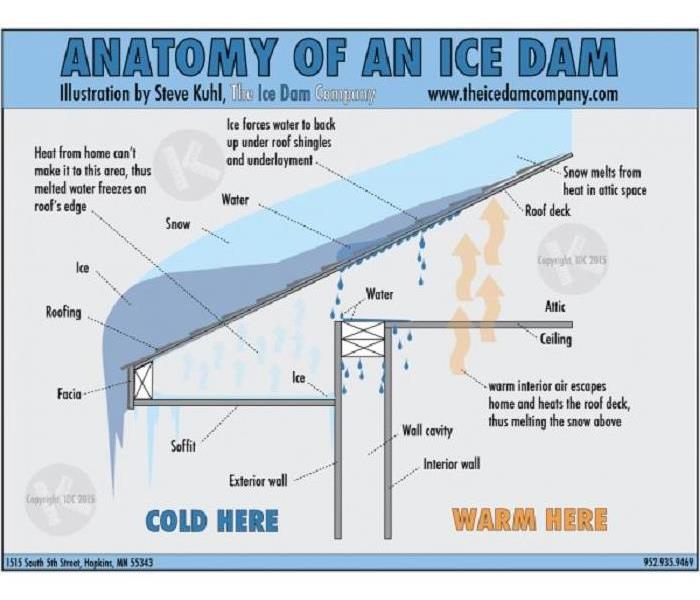 Cross section of a home with an ice dam.
What is an ice dam?
An ice dam is a ridge of ice that forms at the edge of a roof and prevents melting snow (water) from draining off the roof. The water that backs up behind the dam can leak into a home and cause damage to walls, ceilings, insulation, and other areas.
What causes ice dams?
There is a complex interaction among the amount of heat loss from a house, snow cover and outside temperatures that leads to ice dam formation. For ice dams to form there must be snow on the roof, and, at the same time, higher portions of the roof's outside surface must be above 32 degrees F while lower surfaces are below 32. For a portion of the roof to be below 32, outside temperatures must also be below 32. When we say temperatures above or below 32, we are talking about average temperature over sustained periods of time.
The snow on a roof surface that is above 32 will melt. As water flows down the roof it reaches the portion of the roof that is below 32 and freezes. Voila! - an ice dam.
The dam grows as it is fed by the melting snow above it, but it will limit itself to the portions of the roof that are on the average below 32. So the water above backs up behind the ice dam and remains a liquid. This water finds cracks and openings in the exterior roof covering and flows into the attic space. From the attic it could flow into exterior walls or through the ceiling insulation and stain the ceiling finish.
Preventing and dealing with ice dams
Immediate action
- Remove snow from the roof. This eliminates one of the ingredients necessary for the formation of an ice dam. A "roof rake" and push broom can be used to remove snow, but may damage the roofing materials.
- In an emergency situation where water is flowing into the house structure, making channels through the ice dam allows the water behind the dam to drain off the roof. Hosing with tap water on a warm day will do this job. Work upward from the lower edge of the dam. The channel will become ineffective within days and is only a temporary solution to ice dam damage.
Long-term Actions
- First, make the ceiling air tight so no warm, moist air can flow from the house into the attic space.
- After sealing air leakage paths between the house and attic space, consider increasing the ceiling/roof insulation to cut down on heat loss by conduction.The proper new construction practices to prevent ice dams begin with following or exceeding the state code requirements for ceiling/roof insulation levels.Recessed lights, skylights, complicated roof designs, and heating ducts in the attic will all increase the risk of ice dam formation.Moisture entering the home from ice dams can lead to the growth of mold and mildew. These biologicals can cause respiratory problems. It is important that the growth of mold and mildew be prevented. This can be done by immediately calling SERVPRO of Fenton/South Ballwin, 24/7/365 at (636)527-5990 to dry out portions of the house that are wet or damp. Action needs to be taken to clean the home environment and maintain its air quality.
Do You Know Your Zone?
10/31/2018 (Permalink)
We ALL live in a flood zone and we are all at risk of floods damaging our property. MSD wants to encourage homeowners, renters, and business owners to educate themselves on their individual flood risk. A good place to start is with the National Flood Insurance Program. Click the link below to get started!
www.FloodSmart.gov
FLOOD FACTS
Anytime it rains, overland flooding can occur. So that means we ALL live in a flood zone.
Flood risks range from low, moderate, or high. Your insurance will be determined by where you live and the risk of overland flooding.
You don't have to live near a river, creek or stream to be a victim of flood damage.
Twenty percent of all insurance claims come from areas that are not in a high risk flood zone.
The average flood damage claim for homeowners and renters exceeds $35,000 in damages. Most homeowners' insurance does not cover these costs.
Flood insurance is designed to restore your property to its pre-disaster condition. There's no better way to protect the life you've built.
If your home or business is affected by flood waters, SERVPRO of Fenton/South Ballwin is here to help 24/7/365!
restoring lives in Fenton and South Ballwin MO
6/2/2017 (Permalink)
When the record breaking flooding occurred a couple weeks ago St. Louis, MO, we promptly dispatched our SERVPRO of Fenton and South Ballwin teams to assist in the unprecedented recovery efforts. We were very happy to help many grateful business and home owners during their desperate time of need. Our highly trained technicians are water and storm damage specialists. The goal is always the same, to return your commercial or residential property back to pre-storm condition. Using scientific drying techniques and advanced equipment, we document the drying process to insure the business or home is ready to return to. When water damage happens, a quick response is very important. Night or day, St. Louis business owners and residents can expect our local team of professionals to respond immediately to your water emergency. So give us a call at (636) 527-5990
Quick Helpful Tips For Working With Your Insurance For Restoration
5/25/2017 (Permalink)
Regular life is stressful enough, but if you are surprised with flooding or other water damage in your home, everyone in the household will be stressed. Whether the recent St. Louis flood damage leaves carpeting soaked and soggy or you have come back to a disaster after evacuation, severe weather and damaged pipes will cause significant worry about how to start putting back together your daily life.
However, you can prepare for these unknowns by knowing what to expect and create a plan in case of emergency. To assist you, SERVPRO of Fenton and South Ballwin has put together this mini-guide to help you understand the flood insurance claim process.
The first thing you will want to do is call your insurance provider. Although the U.S. government funds the National Flood Insurance Program (NFIP), local home and rental insurance companies are the exclusive sellers of Flood Damage Insurance. While you will be working directly with an insurance agent, SERVPRO can also serve as a liaison, helping you to navigate through the claims process.
After your initial call to your insurance company, contact your Fenton or South Ballwin at 636-527-5990. We are available every day, all day, to handle your emergencies. Even if you are not able to reach your insurance agent immediately, SERVPRO will take your call and begin to work with you on first response remediation solutions. Have questions about what to do first or what items can be restored? SERVPRO is here to answer those questions and more! Our compassionate team understands your distress and will guide you through the storm damage restoration process.
Now you can begin your water damage restoration. We pride ourselves on having the fastest response time to storm damage in your area. We will arrive at your home prepared to conduct an inspection and moisture readings, create a scope of the damage and provide an estimate for you and your insurance provider. Our team will arrive prepared and ready to start immediately. Using our dedicated SERVPRO Claims Information Center (CIC) we can store and access your information easily and quickly.
Our SERVPRO team members are the premier flood and water damage restoration experts in The Fenton and South Ballwin surrounding areas. We are also the preferred remediation team for home insurance providers, and the most trusted helper for storm disasters. Storm damage restoration and navigating flood insurance claims can feel stressful, but we are here to assist you with every stage of the recovery process.
For emergencies and other situations, call 636-527-5990 anytime to reach your area flood damage experts, SERVPRO Fenton and South Ballwin. We help residential and commercial property owners when natural disasters, water damage, sewer backups, floods, mold infestations, fires and other events happen.


 24/7 Emergency Service
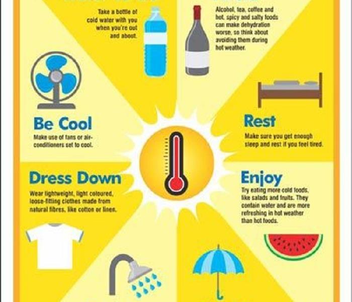
